Task A. Radio Communications Procedures
| Task A. Radio Communications Procedures | |
| References | AC 107-2; AIM; FAA-H-8083-25; FAA-G-8082-22 |
| Objective | To determine that the applicant is knowledgeable in radio communication procedures. |
| Knowledge | The applicant demonstrates understanding of: |
| UA.V.A.K1 | Airport operations with and without an operating control tower. |
| UA.V.A.K2 | The description and use of a Common Traffic Advisory Frequency (CTAF) to monitor manned aircraft communications. |
| UA.V.A.K3 | Recommended traffic advisory procedures used by manned aircraft pilots such as self-announcing of position and intentions. |
| UA.V.A.K4 | Aeronautical advisory communication station (UNICOM) and associated communication procedures used by manned aircraft pilots. |
| UA.V.A.K5 | Automatic Terminal Information Service (ATIS). |
| UA.V.A.K6 | Aircraft call signs and registration numbers. |
| UA.V.A.K7 | The phonetic alphabet. |
| UA.V.A.K8 | Phraseology: altitudes, directions, speed, and time. |
| Risk Management | [Reserved] |
| Skills | [Not Applicable] |
UA.V.A.K1 Airport operations with and without an operating control tower (FAA-H-8083-25 pg. 14-2)
Towered Airport
A towered airport has an operating control tower. Air traffic control (ATC) is responsible for providing the safe, orderly, and expeditious flow of air traffic at airports where the type of operations and/or volume of traffic requires such a service. Pilots operating from a towered airport are required to maintain two-way radio communication with ATC and to acknowledge and comply with their instructions. Pilots must advise ATC if they cannot comply with the instructions issued and request amended instructions. A pilot may deviate from an air traffic instruction in an emergency, but must advise ATC of the deviation as soon as possible.
Nontowered Airport
A nontowered airport does not have an operating control tower. Two-way radio communications are not required, although it is a good operating practice for pilots to transmit their intentions on the specified frequency for the benefit of other traffic in the area. The key to communicating at an airport without an operating control tower is selection of the correct common frequency. The acronym CTAF, which stands for Common Traffic Advisory Frequency, is synonymous with this program. A CTAF is a frequency designated for the purpose of carrying out airport advisory practices while operating to or from an airport without an operating control tower. The CTAF may be a Universal Integrated Community (UNICOM), MULTICOM, Flight Service Station (FSS), or tower frequency and is identified in appropriate aeronautical publications. UNICOM is a nongovernment air/ground radio communication station that may provide airport information at public use airports where there is no tower or FSS. On pilot request, UNICOM stations may provide pilots with weather information, wind direction, the recommended runway, or other necessary information. If the UNICOM frequency is designated as the CTAF, it is identified in appropriate aeronautical publications.
UA.V.A.K2 The description and use of a Common Traffic Advisory Frequency (CTAF) to monitor manned aircraft communications (AIM 4-1-9)
The key to communicating at an airport without an operating control tower is selection of the correct common frequency. The acronym CTAF which stands for Common Traffic Advisory Frequency, is synonymous with this program. A CTAF is a frequency designated for the purpose of carrying out airport advisory practices while operating to or from an airport without an operating control tower. The CTAF may be a UNICOM, MULTICOM, FSS, or tower frequency and is identified in appropriate aeronautical publications.
Authors Note:
There are several ways to determine a CTAF frequency for an airport.

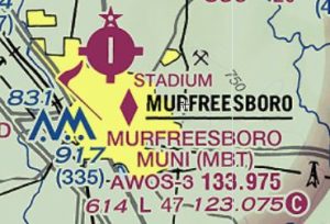
On an aeronautical sectional chart, locate the airport you will be operating near. In this example you will be operating near Murfreesboro Municipal Airport (MBT). MBT is a non-towered airport in Class G airspace. CTAF frequency is indicated by a C, sometimes referred to as “ball C”. Legend 1 Airport Data in the Remote Pilot Testing Supplement will provide you with sectional aeronautical chart symbols and there meanings.
In this example the CTAF for MBT is 123.075. Since there is no other frequency beside the AWOS-3, CTAF also serves as the UNICOM frequency. See UA.V.A.K4 for information on UNICOM.
Note: When no CTAF frequency is shown for an airport on an aeronautical sectional chart, then the CTAF frequency defaults to 122.9.

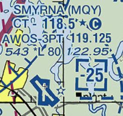
In this example you will be operating near Smyrna Airport (MQY). MQY is a towered airport in Class D airspace. Airports having control towers are shown in blue. Also note that the letters CT followed by a frequency indicate the control tower primary frequency.
The control tower frequency for MQY is 118.5. Notice that the frequency is followed by a star (*) and ball C. The star (*) indicates that the tower is part-time. Refer to the Chart Supplement for tower operating hours. The ball C after the star (*) indicates that the tower frequency, 118.5, becomes the CTAF frequency when the tower is closed. During tower operations, inbound pilots will contact MQY on 118.5 by stating “Smyrna Tower …..“. When the tower is closed, inbound and outbound pilots will announce on UNICOM frequency “Smyrna traffic…..“.
Note that there is an additional frequency of 122.95. This is the UNICOM frequency also know as the Aeronautical Advisory Station for MQY. See UA.V.A.K4 for information on UNICOM.

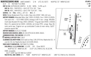
You can also find the CTAF and UNICOM frequency’s in the Chart Supplement formally known as the Airport Facilities Directory. Consult the Communications section. You can find airport chart supplements at the FAA Basic Search website.
UA.V.A.K3 Recommended traffic advisory procedures used by manned aircraft pilots such as self-announcing of position and intentions (AIM 4-1-9)
Recommended Traffic Advisory Practices
- Pilots of inbound traffic should monitor and communicate as appropriate on the designated CTAF from 10 miles to landing. Pilots of departing aircraft should monitor/communicate on the appropriate frequency from start‐up, during taxi, and until 10 miles from the airport unless the CFRs or local procedures require otherwise.
- Pilots of aircraft conducting other than arriving or departing operations at altitudes normally used by arriving and departing aircraft should monitor/communicate on the appropriate frequency while within 10 miles of the airport unless required to do otherwise by the CFRs or local procedures. Such operations include parachute jumping/dropping, en route, practicing maneuvers, etc.
- In Alaska, pilots of aircraft conducting other than arriving or departing operations in designated CTAF areas should monitor/communicate on the appropriate frequency while within the designated area, unless required to do otherwise by CFRs or local procedures. Such operations include parachute jumping/dropping, en route, practicing maneuvers, etc.
UA.V.A.K4 Aeronautical advisory communication station (UNICOM) and associated communication procedures used by manned aircraft pilots (AIM 4-1-9)
Information Provided by Aeronautical Advisory Stations (UNICOM)
- UNICOM is a nongovernment air/ground radio communication station which may provide airport information at public use airports where there is no tower or FSS.
- On pilot request, UNICOM stations may provide pilots with weather information, wind direction, the recommended runway, or other necessary information. If the UNICOM frequency is designated as the CTAF, it will be identified in appropriate aeronautical publications.
UA.V.A.K5 Automatic Terminal Information Service (ATIS) (AIM 4-1-13)
- ATIS is the continuous broadcast of recorded non-control information in selected high activity terminal areas. Its purpose is to improve controller effectiveness and to relieve frequency congestion by automating the repetitive transmission of essential but routine information. The information is continuously broadcast over a discrete VHF radio frequency or the voice portion of a local NAVAID. Arrival ATIS transmissions on a discrete VHF radio frequency are engineered according to the individual facility requirements, which would normally be a protected service volume of 20 NM to 60 NM from the ATIS site and a maximum altitude of 25,000 feet AGL. In the case of a departure ATIS, the protected service volume cannot exceed 5 NM and 100 feet AGL. At most locations, ATIS signals may be received on the surface of the airport, but local conditions may limit the maximum ATIS reception distance and/or altitude. Pilots are urged to cooperate in the ATIS program as it relieves frequency congestion on approach control, ground control, and local control frequencies. The Chart Supplement indicates airports for which ATIS is provided.
- ATIS information includes:
- Airport/facility name
- Phonetic letter code
- Time of the latest weather sequence (UTC)
- Weather information consisting of:
- Wind direction and velocity
- Visibility
- Obstructions to vision
- Present weather consisting of: sky condition, temperature, dew point, altimeter, a density altitude advisory when appropriate, and other pertinent remarks included in the official weather observation
- Instrument approach and runway in use.
The ceiling/sky condition, visibility, and obstructions to vision may be omitted from the ATIS broadcast if the ceiling is above 5,000 feet and the visibility is more than 5 miles. The departure runway will only be given if different from the landing runway except at locations having a separate ATIS for departure. The broadcast may include the appropriate frequency and instructions for VFR arrivals to make initial contact with approach control. Pilots of aircraft arriving or departing the terminal area can receive the continuous ATIS broadcast at times when cockpit duties are least pressing and listen to as many repeats as desired. ATIS broadcast must be updated upon the receipt of any official hourly and special weather. A new recording will also be made when there is a change in other pertinent data such as runway change, instrument approach in use, etc.EXAMPLE-
Dulles International information Sierra. One four zero zero zulu. Wind three five zero at eight. Visibility one zero. Ceiling four thousand five hundred broken. Temperature three four. Dew point two eight. Altimeter three zero one zero. ILS runway one right approach in use. Departing runway three zero. Advise on initial contact you have information sierra.
- Pilots should listen to ATIS broadcasts whenever ATIS is in operation.
- Pilots should notify controllers on initial contact that they have received the ATIS broadcast by repeating the alphabetical code word appended to the broadcast.
EXAMPLE-
“Information Sierra received.”
- When a pilot acknowledges receipt of the ATIS broadcast, controllers may omit those items contained in the broadcast if they are current. Rapidly changing conditions will be issued by ATC and the ATIS will contain words as follows:
EXAMPLE-
“Latest ceiling/visibility/altimeter/wind/(other conditions) will be issued by approach control/tower.”
NOTE-
The absence of a sky condition or ceiling and/or visibility on ATIS indicates a sky condition or ceiling of 5,000 feet or above and visibility of 5 miles or more. A remark may be made on the broadcast, “the weather is better than 5000 and 5,” or the existing weather may be broadcast.
- Controllers will issue pertinent information to pilots who do not acknowledge receipt of a broadcast or who acknowledge receipt of a broadcast which is not current.
- To serve frequency limited aircraft, FSSs are equipped to transmit on the omnirange frequency at most en route VORs used as ATIS voice outlets. Such communication interrupts the ATIS broadcast. Pilots of aircraft equipped to receive on other FSS frequencies are encouraged to do so in order that these override transmissions may be kept to an absolute minimum.
- While it is a good operating practice for pilots to make use of the ATIS broadcast where it is available, some pilots use the phrase “have numbers” in communications with the control tower. Use of this phrase means that the pilot has received wind, runway, and altimeter information ONLY and the tower does not have to repeat this information. It does not indicate receipt of the ATIS broadcast and should never be used for this purpose.
UA.V.A.K6 Aircraft call signs and registration numbers (FAA-G-8082-22 pg. 41)
When operating in the vicinity of any airport, either towered or non-towered, it is important for a remote pilot to understand radio communications of manned aircraft in the area. Although 14 CFR part 107 only requires the remote pilot to receive authorization to operate in certain airport areas, it can be a good operating practice to have a radio that will allow the remote pilot to monitor the appropriate frequencies in the area. The remote pilot should refrain from transmitting over any active aviation frequency unless there is an emergency situation.
Aviation has unique communication procedures that will be foreign to a remote pilot who has not been exposed to “aviation language” previously. One of those is aircraft call signs. All aircraft that are registered in the United States will have a unique registration number, or “N” number. For example, N123AB, which would be pronounced in aviation terms by use of the phonetic alphabet as, “November One-Two-Three-Alpha-Bravo.” In most cases, “November” will be replaced with either the aircraft manufacturer’s name (make) and in some cases, the type of aircraft (model). Usually, when the aircraft is a light general aviation (GA) aircraft, the manufacturer’s name will be used. In this case, if N123AB is a Cessna 172, the call sign would be “Cessna, One-Two-Three-Alpha-Bravo.” If the aircraft is a heavier GA aircraft, such as a turbo-prop, or turbo-jet, the aircraft’s model will be used in the call sign. If N123AB is a Cessna Citation, the call sign would be stated as, “Citation, OneTwo-Three-Alpha-Bravo.” Typically, airliners will use the name of their companies and their flight number in their call signs. For example, Southwest Airlines flight 711, would be said as, “SouthwestSeven-One-One.” There are a few airlines such as British Airways who will not use the company name in their call sign. For example, British Airways uses “Speedbird.”
To close, a remote pilot is not expected to communicate with other aircraft in the vicinity of an airport, and should not do so unless there is an emergency situation. However, in the interest of safety in the NAS, it is important that a remote pilot understands the aviation language and the types of aircraft that can be operating in the same area as a small UA
UA.V.A.K7 The phonetic alphabet (AIM 4-2-7)
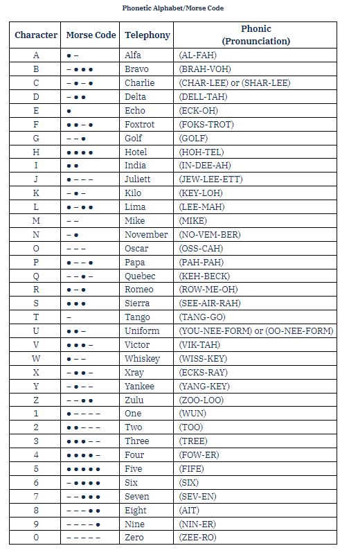
The International Civil Aviation Organization (ICAO) phonetic alphabet is used by FAA personnel when communications conditions are such that the information cannot be readily received without their use. ATC facilities may also request pilots to use phonetic letter equivalents when aircraft with similar sounding identifications are receiving communications on the same frequency. Pilots should use the phonetic alphabet when identifying their aircraft during initial contact with air traffic control facilities. Additionally, use the phonetic equivalents for single letters and to spell out groups of letters or difficult words during adverse communications conditions.

UA.V.A.K8 Phraseology: altitudes, directions, speed, and time (AIM 4-2-8, 9, 10, 11, & 12)
Figures (AIM 4-2-8)
- Figures indicating hundreds and thousands in round number, as for ceiling heights, and upper wind levels up to 9,900 must be spoken in accordance with the following.
EXAMPLE-
- 500 . . . . . . . .five hundred
- 4,500 . . . . . . . .four thousand five hundred
- Numbers above 9,900 must be spoken by separating the digits preceding the word “thousand.”
EXAMPLE-
- 10,000 . . . . . . . .one zero thousand
- 13,500 . . . . . . . .one three thousand five hundred
- Transmit airway or jet route numbers as follows.
EXAMPLE-
- V12. . . . . . . .Victor Twelve
- J533. . . . . . . .J Five Thirty-Three
- All other numbers must be transmitted by pronouncing each digit.
EXAMPLE-
10 . . . . . . . .one zero
When a radio frequency contains a decimal point, the decimal point is spoken as “POINT.”
EXAMPLE-
122.1. . . . . . . .one two two point one
NOTE-
ICAO procedures require the decimal point be spoken as “DECIMAL.” The FAA will honor such usage by military aircraft and all other aircraft required to use ICAO procedures.
Altitudes and Flight Levels (AIM 4-2-9)
- Up to but not including 18,000 feet MSL, state the separate digits of the thousands plus the hundreds if appropriate.
EXAMPLE-
- 12,000 . . . . . . . .one two thousand
- 12,500 . . . . . . . .one two thousand five hundred
At and above 18,000 feet MSL (FL 180), state the words “flight level” followed by the separate digits of the flight level.
EXAMPLE-
- 190 . . . . . . . .Flight Level One Niner Zero
- 275 . . . . . . . .Flight Level Two Seven Five
Directions (AIM 4-2-10)
The three digits of bearing, course, heading, or wind direction should always be magnetic. The word “true” must be added when it applies.
EXAMPLE-
- (Magnetic course) 005 . . . . . . . .zero zero five
- (True course) 050 . . . . . . . .zero five zero true
- (Magnetic bearing) 360 . . . . . . . .three six zero
- (Magnetic heading) 100 . . . . . . . .heading one zero zero
- (Wind direction) 220 . . . . . . . .wind two two zero
Speeds (AIM 4-2-11)
The separate digits of the speed followed by the word “KNOTS.” Except, controllers may omit the word “KNOTS” when using speed adjustment procedures; e.g., “REDUCE/INCREASE SPEED TO TWO FIVE ZERO.”
EXAMPLE-
(Speed) 250 . . . . . . . . two five zero knots
(Speed) 190 . . . . . . . . one niner zero knots
The separate digits of the Mach Number preceded by “Mach.”
EXAMPLE-
(Mach number) 1.5 . . . . . . . .Mach one point five
(Mach number) 0.64. . . . . . . .Mach point six four
(Mach number) 0.7. . . . . . . .Mach point seven
Time (AIM 4-2-12)
- FAA uses Coordinated Universal Time (UTC) for all operations. The word “local” or the time zone equivalent must be used to denote local when local time is given during radio and telephone communications. The term “Zulu” may be used to denote UTC.
EXAMPLE-
0920 UTC. . . . . . . .zero niner two zero,
zero one two zero pacific or local,
or one twenty AM - To convert from Standard Time to Coordinated Universal Time:
| Eastern Standard Time | Add 5 hours |
| Central Standard Time | Add 6 hours |
| Mountain Standard Time | Add 7 hours |
| Pacific Standard Time | Add 8 hours |
| Alaska Standard Time | Add 9 hours |
| Hawaii Standard Time | Add 10 hours |
-
NOTE-
For daylight time, subtract 1 hour.
- A reference may be made to local daylight or standard time utilizing the 24-hour clock system. The hour is indicated by the first two figures and the minutes by the last two figures.
EXAMPLE-
0000 . . . . . . . . zero zero zero zero
0920 . . . . . . . . zero niner two zero - Time may be stated in minutes only (two figures) in radiotelephone communications when no misunderstanding is likely to occur.
Current time in use at a station is stated in the nearest quarter minute in order that pilots may use this information for time checks. Fractions of a quarter minute less than 8 seconds are stated as the preceding quarter minute; fractions of a quarter minute of 8 seconds or more are stated as the succeeding quarter minute.
EXAMPLE-
0929:05 . . . . . . . .time, zero niner two niner
0929:10 . . . . . . . .time, zero niner two niner and one-quarter

